


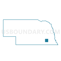
South Fork Precinct, Saline County, Nebraska
About
Outline

Summary
| Unique Area Identifier | 613789 |
| Name | South Fork Precinct |
| County | Saline County |
| State | Nebraska |
| Area (square miles) | 72.05 |
| Land Area (square miles) | 71.98 |
| Water Area (square miles) | 0.07 |
| % of Land Area | 99.91 |
| % of Water Area | 0.09 |
| Latitude of the Internal Point | 40.43640930 |
| Longtitude of the Internal Point | -97.19597610 |
Maps


Graphs
Select a template below for downloading or customizing gragh for South Fork Precinct, Saline County, Nebraska


Neighbors
Neighoring Voting District (by Name) Neighboring Voting District on the Map
- Dewitt Precinct, Saline County, NE
- Dorchester Precinct, Saline County, NE
- Eur-Wash Precinct, Jefferson County, NE
- Friend Ward 2, Saline County, NE
- Olive Precinct, Saline County, NE
- Ply-Gib Precinct, Jefferson County, NE
- Wilbur 1 Precinct, Saline County, NE
Top 10 Neighboring County Subdivision (by Population) Neighboring County Subdivision on the Map
- South Fork precinct, Saline County, NE (334)
- Olive precinct, Saline County, NE (240)
- Pleasant Hill precinct, Saline County, NE (184)
- Swan Creek precinct, Saline County, NE (180)
- Brush Creek precinct, Saline County, NE (140)
- Washington precinct, Jefferson County, NE (127)
- North Fork precinct, Saline County, NE (122)
- Gibson precinct, Jefferson County, NE (116)
- Atlanta precinct, Saline County, NE (108)
- Monroe precinct, Saline County, NE (97)
Top 10 Neighboring Place (by Population) Neighboring Place on the Map
Top 10 Neighboring Unified School District (by Population) Neighboring Unified School District on the Map
- Fairbury Public Schools, NE (5,796)
- Wilber-Clatonia Public Schools, NE (3,106)
- Tri County Public Schools, NE (2,316)
- Exeter-Milligan Public Schools, NE (1,519)
- Friend Public Schools, NE (1,474)
- Dorchester Public Schools, NE (1,117)
- Meridian Public Schools, NE (968)
Top 10 Neighboring State Legislative District Upper Chamber (by Population) Neighboring State Legislative District Upper Chamber on the Map
Top 10 Neighboring 111th Congressional District (by Population) Neighboring 111th Congressional District on the Map
Top 10 Neighboring Census Tract (by Population) Neighboring Census Tract on the Map
Top 10 Neighboring 5-Digit ZIP Code Tabulation Area (by Population) Neighboring 5-Digit ZIP Code Tabulation Area on the Map
- 68465, NE (2,404)
- 68359, NE (1,585)
- 68343, NE (1,050)
- 68464, NE (478)
- 68406, NE (458)
- 68338, NE (324)
- 68453, NE (304)